
Vildisora. Vildisot. Vil di miec. That is, Tramonti di Sopra, Tramonti di Sotto and Tramonti di Mezzo, the three localities that, together with Meduno, form the Val Tramontina, a mountain valley that is a hidden treasure nestled among the peaks of the western Friuli. An corner of Italy enriched by remarkable natural beauty, such as the famous Emerald Ponds of the Meduna River or the summits of the Friulian Dolomites, yet with many trails, hikes and experiences that still lie outside the main tourism circuits and that allow visitors to explore the woods, the valleys, the passes and the ridges with the quiet, calm and attentiveness that make a trip feel more complete and satisfying.
The Val Tramontina is a land that, moreover, has emptied out as time has passed. The town of Tramonti di Sotto counted more than three thousand inhabitants at the start of the twentieth century; today there are just over 300. A mountain that progressively emptied as agricultural and livestock activities in the interior areas dwindled and the countryside became increasingly deserted. A historical process that, like any other, leaves tangible testimonies: this is what happened to Palcoda and Tamar, two clusters of stone houses perched in the heart of the Carnic Prealps, which nature has slowly reclaimed over the last century. Small ghostly mountain villages, today partly restored to new splendor as refuges, bivouacs and spaces to best enjoy a splendid mountain setting, linked by a beautiful circular trail that allows you to traverse an unspoiled and wonderfully beautiful nature.
Val Tramontina: where it is and how to get there
The Val Tramontina lies in the western part of Friuli, in the province of Pordenone, tucked between the Carnic Prealps and entirely inside the Dolomiti Friulane Natural Park. Its name is thought to derive from the Latin intra montes, meaning “between the mountains” and indeed describes a secluded valley enclosed by ridges that for centuries kept it on the margins of major routes.
The two main municipalities are Tramonti di Sopra and Tramonti di Sotto. In the lower part of the valley lies the surface of Lake Tramonti, or Redona Lake: an artificial basin created in 1952 by damming the Meduna torrent, which at that time also submerged the ancient village of Movada, whose remnants reemerge during dry periods, as in the just-passed summer.
To reach the valley from Pordenone and the Friulian plain, take Regional Road 552, passing through Spilimbergo, Sequals and Meduno up to Tramonti di Sotto. Those arriving from the Carnia can opt for the more scenographic route that crosses the Rest Pass, a hairpin turn after hairpin turn through woods and sheer rock faces, a route beloved by motorcyclists as well.
It is a valley that has experienced, like much of the Alpine arc, a long and progressive abandonment: it is home to more than 150 settlements, hamlets and dispersed stone houses scattered in its valleys, many of which today lie in ruins or are completely swallowed by vegetation. Once livelihoods depended on pasture, alpine farming and artisanal crafts; today the territory holds immense natural value and is frequented mainly by hikers, and gastronomically known for pitina, a smoked sausage made from sheep and goat meat, which has obtained the IGP designation precisely in this area.
The hike towards Palcoda
The starting point to reach the two abandoned villages of Palcoda and Tamar is the town of Tramonti di Sotto. From the center of the village one enters Via Manzoni and, by car, reaches Comesta. Here a no-entry sign marks the actual start of the walk, and you can leave the car at a clearing with a mural that recalls the Resistance among these peaks.
After just a few meters the path crosses the Tarcenò torrent and the actual hike begins: at the junction one follows the CAI 831A trail toward Palcoda, while the other path is the one that will bring you to the end of the loop. The first stretch is the most demanding, climbing through beech forests and more open areas from which you overlook the valley of Tramonti and gain a splendid view of the Friulian Dolomites. The landscape progressively opens to include views as far as Col Nudo and Monte Cavallo, while the Tarcenò torrent offers along the way small waterfalls and basins carved into the calcareous rock over the millennia.
Beyond a saddle, the ascent ends. The trail then descends toward the valley of the Chiarzò torrent, and the first village to appear along the route that runs right beside the watercourse is Palcoda.
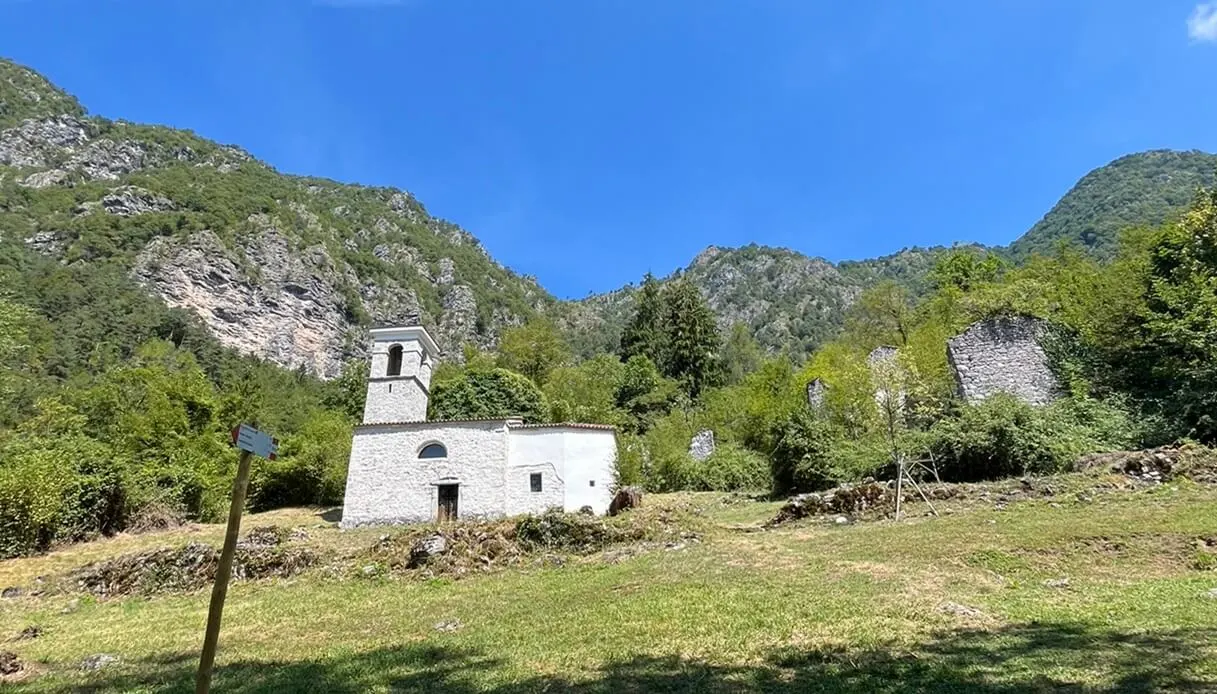
Today the ancient village retains essentially only the Church of San Giacomo, restored in 2011: its white bell tower stands out amid the woods and can be seen from a long distance. When you reach the wide clearing, shaded by walnut trees, you can approach its tower and pull the rope to ring the bell. Inside the church, a few informative panels recount the story of the building’s renovation. Outside, next to it, a bivouac set up by volunteers is a splendid example of the cooperative spirit and sharing that you find in the mountains. The rest of the old village consists of stone houses that have fallen into ruin, swallowed by brambles, trees and nature.
Nevertheless, the story of Palcoda is long: the first traces of habitation date back to the fifteenth century, when the area was frequented by passing shepherds; from the seventeenth century Palcoda became a permanent settlement, thanks above all to the Moruzzi and Masutti families, who were the first to settle there and who would remain the steady protagonists of village life. In its height, during the seventeenth century, the town had about 150 inhabitants, a mill, a furnace, and an economy that partly relied on hat making, exported beyond the Val Tramontina.
The decline began in the early decades of the twentieth century, when depopulation toward the plains and cities gradually emptied the houses. During World War II Palcoda briefly became inhabited again, or rather frequented: it served as a refuge for partisans of the Resistance, and precisely among its houses, in December 1944, three young partisans were captured and executed. A plaque near the church commemorates them.
The great waterfall of Chiarzò and Tamar
From Palcoda you reach Tamar, and then return to the starting point via the CAI 832 trail, which passes by the Guado Tarcenò and closes the loop.
Along the way, however, a short detour to the Pisulat waterfall is mandatory, a true natural monument: a majestic plunge of the Chiarzò torrent, extremely scenic, and in summer especially pleasant for the possibility of diving and swimming in the large crystalline pool that forms at the foot of the waterfall.
To reach this splendid spot, turn north at the crossing of the Chiarzò, onto the path from Palcoda toward Tamar. The detour is brief, requiring only about ten minutes to stand before this marvelous cascade. Then you return on your steps to resume the descent toward Tamar.
A twin village to Palcoda in history and destiny, Tamar experienced a slower trajectory of abandonment. Here the last inhabitant, an elderly woman, left the town only in the 1950s, sealing its fate as a permanent community. Today Tamar is a restored and fully usable structure, with a bivouac and a small well-equipped refuge available to hikers. It is an ideal place for a break, in a green clearing with leafy trees and soft meadows.
From Tamar, you then tackle the final descent to return to the starting point, winding down a series of switchbacks through a splendid forest of oaks, beeches and birches.
Overall, the hike spans roughly 10 kilometers, with a elevation gain of around 500 meters. It is suitable for all levels of experience, but it remains challenging and requires decent physical condition. The total time for the round trip is about four hours.