
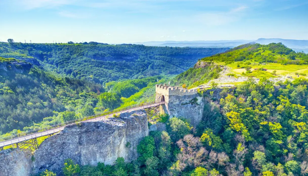
To the east of Provadia, in Bulgaria, a vast stone plateau rises before the eye, almost like a natural platform lifted above the valley. It is Kaleto, the name by which the outcrop hosting the Fortezza di Ovech is known, one of the region’s most singular historical testimonies in the Varna area.
The promontory presents itself rugged, isolated, and protected by cliffs rising between 11 and 25 meters. A position that, whether by design or fortune, already offered formidable defence (without needing to rely solely on walls and towers). Then there is a long bridge that connects the fortified complex to the nearby Tabiite plateau, while above remain traces of a community that for centuries fulfilled military, administrative, religious, and economic functions. Those who reach this point, therefore, enter a historical landscape built on a truly unusual natural formation.
Ovech also has a curious feature tied to its name: the different peoples who inhabited the site called it in different ways. The Byzantines referred to it as Provat, Bulgarians as Ovech, and the Ottomans as Tash Hisar, a Turkish expression translatable as “stone fortress“.
A Brief History of the Ovech Fortress
Archaeological research places the use of this fascinating Bulgarian fortress starting from the mid-3rd century. The first phase lasts until the early decades of the 7th century, followed by a gap and a renewed occupation between the 10th and 11th centuries. The settlement remained active until the end of the 17th century, thus traversing a particularly wide succession of eras.
On the plateau, Thracians, Romans, Byzantines, Bulgarians and Ottomans alternated. The most important period coincided with the Second Bulgarian Empire, i.e. when Ovech became a prominent military, religious, administrative and economic center, favored by its strategic position relative to Varna and the routes leading to the Black Sea.
The fortress also preserves memories of events tied to the local medieval history: the years of Tsar Ivaylo’s reign, between 1277 and 1280, the crusade led in 1366 by Amadeus VI of Savoy, and the expedition of the Polish–Hungarian king Ladislaus III Jagellon in 1444. The latter phase belongs to the period of campaigns against the Ottoman Empire.
The site is also linked to the rebellion of Tsar Constantine’s sons and Frujin, and to the long phase of Ottoman expansion in the Balkans. The fortress stones thus tell a story made of sieges, armies, political power and territorial control.
What to See and Do at the Ovech Fortress
Visiting requires at least 40 minutes, though it is worth allowing more time to observe the plateau and the panorama carefully. The site is open year-round, and on-site there are informational materials, souvenirs and a guide assigned by the Provadia History Museum.
The Bridge to Tabiite
The large wooden structure is the fortress’s most recognizable symbol and connects Ovech’s northern entrance to the Tabiite plateau. The whole crossing traverses a terrain that is particularly scenic.
Passing over it means having the fortress in front of you and the valley beneath your gaze. In windy conditions the sensation becomes even more intense, especially along the central stretch of the path.
The Western Staircase
From the Provadia side the fortress is reached via a spiral staircase of 111 steps. The ascent follows the rock’s contour and immediately reveals the defensive nature of the complex.
It is one of the most distinctive access points, because it allows visitors to physically feel the difficulty an army would have faced in attempting to reach the plateau.
The Eastern Steps
On the eastern side there is still visible an access with steps carved directly into the rock. The structure has preserved its original form and offers a second way to reach the site.
The man-made rockwork appears particularly evocative beside the plateau’s natural walls.
The Medieval Churches
On the plateau the foundations of three medieval churches have been identified. One of them served a metropolitan function, confirming the religious importance that Ovech reached during the Second Bulgarian Empire.
There are also remains of dwellings, commercial structures and traces of roads. In the area of the ancient central square, vestiges of a real district formed during the fortress’s peak have been uncovered.
The 79-Metre Well
Among the most unusual attractions is, without a doubt, a well 79 metres deep, remembered as the “talking well”. The presence of such a structure had enormous practical importance for a fortress perched on a plateau.
The complex also included 13 cisterns intended for collecting rainwater and storing grain. These elements provide a tangible image of daily life inside the fortress, made up of supplies, stock and spatial organization.
The Knights’ Prison and the Devil’s Path
Finally, the knights’ prison, the tower linked to the so-called Devil’s Path, and the Friars’ holes, caverns remembered among the site’s peculiarities.
Beside the archaeological structures, the panorama remains one of the strongest reasons to reach Kaleto: Provadia appears below, surrounded by the region’s landscape, while the plateau profiles make evident the strategic rationale behind the choice.
Where It Is and How to Get There
Provadia is located about 53 km west of Varna and roughly 410 km east of Sofia. The distance from Varna makes Ovech a convenient stop on a tour of northeastern Bulgaria. By car from Varna, follow the A2 Hemus motorway west, then take the Provadia exit and the 208 road into the town center. The journey takes about 40–50 minutes. From Varna Airport, travel time is similar.
Provadia is also reachable by train and bus: from the town’s railway or bus station it takes about 20–30 minutes on foot to reach the main access points, or a few minutes by taxi.
Once in town, the signage to the fortress is clearly visible. The western access leads to the 111-step staircase, while the eastern slope preserves the stair carved in stone. For those who prefer to arrive by car, the northern parking area is the most practical option and leads to the main entrance and the grand bridge.
Before leaving Ovech, it is worth one last look toward Provadia. From up there the town looks small, almost compressed between the outcrop and the valley. It is precisely this perspective that clarifies the strength of the choice made centuries ago: the fortress had the rock as its first barrier, altitude as the vantage point, and the surrounding territory under visual control.
