
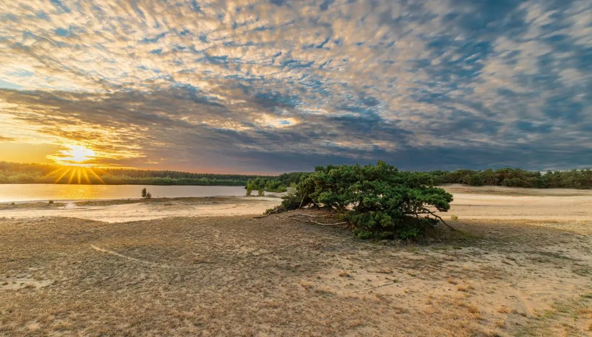
The name, Sahara of Lommel, suggests we have landed in Africa, on a slice of that vast desert that runs across the continent. But no, we’re in Belgium, a country that typically evokes medieval towns, grand squares, castles, and expanses of green. Yet in the northern area there lies a broad stretch of very pale sand, full of wind-shaped dunes and even a turquoise-tinged lake, while tall conifers form a dark frame around it.
In essence, one confronts one of the most unusual natural environments in Belgium, located not far from the border with the Netherlands. It is a small desert, spanning roughly 200 hectares, but the contrast is so striking as to be disorienting: a few steps beyond the pine forest and the ground becomes soft, vegetation thins, and the eye meets a sun-sparkling sandy surface.
Behind this almost exotic scenario hides, however, a story very different from that of the great African deserts. Its origin is tied to industry, to pollution, and to a subsequent environmental transformation that has restored a completely new balance.
Origin and formation of the Sahara of Lommel, the desert born from industry
By the late 19th century much of this Belgian territory was covered with heaths used by agricultural communities, but the arrival of the metallurgical industry completely changed the situation. A few years later, specifically in 1904, construction began of the Société Métallurgique de Lommel, a plant dedicated to zinc production and sulfuric acid.
The inevitable industrial emissions (rich in pollutants and heavy metals) gradually deteriorated the vegetation. It was thus that plants disappeared from large tracts of land, leaving exposed a sandy area particularly vulnerable to the wind.
Within a few decades the situation became striking, so that during the 1930s the area affected by drifting sands had reached about 600 hectares, extending toward the Bocholt-Herentals Canal and the valley of the Klachtloop stream. Gusts carried large quantities of sand into homes, creeping in through doors, windows, and crevices.
What today is considered a small paradise for hikers, therefore, represented a real environmental problem for the population. To counter the advance of the sands, vegetative barriers were created and numerous pines were planted. The roots helped stabilize the ground, while the canopies limited the wind’s erosive effect.
The great blue lake occupies a former sand quarry, formed during the area’s mining activities. Another interesting feature concerns the eastern dunes, known as Wijerkense Bergen: sandy rises created by the accumulation of material carried by the wind. Some pines keep their roots partially exposed, while others have trunks buried by sand up to several meters high.
The Sahara of Lommel is therefore a landscape born from an environmental disaster that, over time, has become one of Flanders’ most peculiar natural attractions, now part of a territory protected by the Natura 2000 network.
Visit the Sahara of Lommel
The area (or rather, the main entrance) welcomes visitors with the House of Nature, a monumental artistic installation created by Will Beckers that serves as the gateway to the Bosland National Park. It stands 7.5 meters tall and 50 meters wide, and is a steel structure with an organic shape, composed of thousands of welded metal elements. Its irregular lines echo the surrounding nature, while a human-shaped opening allows visitors to pass through.
Around it are spaces equipped for picnics, playful installations, and small adventure paths designed also for children. Beyond the entrance, trails wind first through a dark-soil pine forest, then reach the sandy surfaces, until the shade of the trees makes way to light and the great lake appears before the eye.
The water takes on different tones depending on the weather: with the sun high, blue and turquoise prevail, while on cloudy days the surface turns silver. To explore the area, there are three marked hiking routes catering to different needs:
- Blue Route of 3.8 km: ideal for families and a relatively short visit, starting from the House of Nature.
- Orange Route: about 6 km, an intermediate itinerary that allows appreciating several natural environments.
- Red Route: at 11.7 km it is the most complete, weaving through dunes, pine forests, heathlands and the surrounding area. It typically takes about 3 hours.
Among the most fascinating points is certainly the panoramic tower Reus van Bosland, the Bosland Giant, rising 30 meters high, which mirrors the sinuous shapes of the dunes and enables a view from above of the landscape’s distinctive layout. After climbing its 144 steps, the sand appears nestled among large green patches, with the lake drawing a luminous surface at the center.
Also noteworthy is the pedestrian bridge over the Bocholt-Herentals canal, shaped like an S, built in steel and wood and supported by two metal pylons. Crossing it leads to the Blekerheide heathlands, particularly evocative during the purple heather bloom. The longest route also crosses an former area used for explosives and ammunition tests, where among the trees one can glimpse concrete structures, bunkers and abandoned test installations.
The site is open year-round, but spring and autumn generally offer more comfortable temperatures. Summer, on the other hand, enhances the colors of the sand and water.
Where it is and how to get there
The Sahara of Lommel is located in the northern part of Belgium’s Limburg province, in Flanders, a short distance from the town of Lommel and the Dutch border. The destination belongs to the Bosland National Park, a vast protected area full of forests, heaths, dunes, and wetlands.
The main entrance can be reached by car by entering House of Nature, Speelpleinstraat 201, 3920 Lommel, but there is another access point at the De Soeverein sports complex, located at Sportveldenstraat 10. Those who prefer public transport can reach Lommel railway station and continue with bus line 29 to the Lommel Soeverein stop, checking timetables in advance.
Once on site, the network of marked routes lets visitors freely choose the duration of their visit. To enjoy the landscape at a relaxed pace, at least two hours are recommended, while those wishing to tackle the red itinerary should dedicate a good portion of the morning or afternoon to this place.