
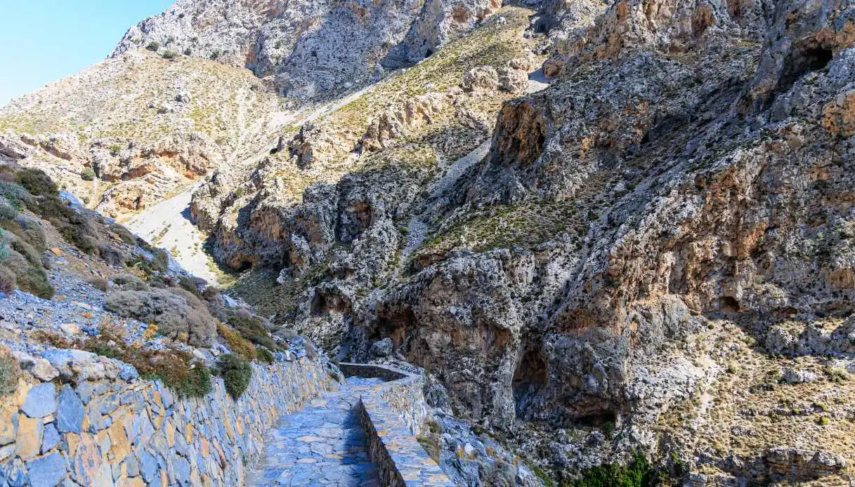
Between the mountains of Crete’s mainland, there is a deep crack in the rock that abruptly interrupts the landscape. In this area, towering limestone walls rise, barely revealing the course of a river, while the wind threads through the fissures, producing strange noises (some swear they resemble the clapping of hands). At the canyon’s bottom, water springs from the stone and plunges into turquoise-hued natural pools, making the whole scene almost fairy-tale-like: it is the Kourtaliotiko Gorge, one of Crete’s most spectacular natural environments.
Located in the southern part of the Rethymno region, it traverses a mountainous territory still deeply linked to the island’s identity. For about 3 kilometers, enormous rocky bastions accompany the Kourtaliotis river southward, toward the Preveli area and the Libyan Sea.
Also known as the Asomatos Gorge, it offers an even more distinctive atmosphere thanks to the presence of a tiny church dedicated to Saint Nicholas, the protagonist of a legend handed down by the locals of the area.
Origin, formation and legends of the Kourtaliotiko Gorge
This splendid showcase of Greek nature did not come about overnight; rather, it is the result of a long geological evolution. The canyon stretches between the Kouroupa and Xiron Oros ridges, in the southern sector of Crete, carved through imposing masses of limestone shaped by water and the movements of the earth’s crust.
Over time, the river’s erosive action deepened preexisting fractures, helping to carve out a narrow natural passage. The walls reach considerable heights and display irregular surfaces, cavities, and clearly distinguishable rock strata.
From above, the valley floor appears almost flattened between two gigantic walls of rock, a sight that, in some respects, has a surreal quality. The rocks take on gray, ochre, and reddish tones, while vegetation concentrates in the crevices and in the damp spots.
An essential element of this environment is represented by the Saint Nicholas springs, fed by underground waters that flow through the geological formations of the area. Thanks to these inputs, the river system retains water even during the summer months, a particularly valuable feature in the island’s Mediterranean climate.
Beyond geology, there is also a more curious side: the name Kourtaliotiko is closely tied to an acoustic phenomenon that has fueled folk tales for generations. The Greek word kourtala indeed evokes the sound of hands clapping together. According to tradition, when the wind passes through the openings (which in some spots are truly narrow) it produces dry, repeating sounds, sometimes resembling applause.
Even more fascinating is the legend of the five Saint Nicholas springs, linked to a small (yet particularly pretty) church built at the foot of the western wall. The tale says that the saint struck the rock with the five fingers of his hand, from which water miraculously gushed forth, giving rise to the springs that still feed the waterfalls today.
Visiting the Kourtaliotiko Gorge
The first emotion this Greek gorge offers is already felt from the scenic road that crosses it. The asphalt indeed follows the curves of the mountain, while enormous rock faces rise all around. To reach the main attractions, however, you must descend along the equipped pedestrian path, characterized by stone steps, rocky stretches, and surfaces that can become slippery.
The central route recommended for the visit measures about 2 kilometers round trip, and leads to the Chapel of Saint Nicholas and the waterfall area. Access to the organized part of the gorge is regulated, with a ticketing system and staff on duty to supervise.
Descending among the rocks, the noisy traffic (especially in high season) fades away and gives space to the rush of water, which, step by step, grows stronger. Then the Church of Agios Nikolaos comes into view, set in a limestone-dominated environment, with its simple shapes contrasting with the grandeur of the surrounding walls.
A short distance away lie the famous springs and the Kourtaliotiko waterfalls, among the most recognizable images of southern Crete. Water emerges from the rocks, plunges along the walls, and collects in natural, exceptionally clear basins. Be careful, though, because the water temperatures are quite cold even in summer, around 14 °C.
Nature lovers will learn that these rock walls also shelter numerous birds of prey, including the griffon, the golden eagle, the Bonelli’s eagle, and the rare bearded vulture, recognizable for its distinctive silhouette and long wedge-shaped tail. Looking up (especially during hours favorable to rising air currents), one can observe large birds slowly gliding over the mountains.
The vegetation also tells the canyon’s story: on the drier slopes, Mediterranean shrubs and aromatic herbs thrive, while along the river there are plants tied to moist environments. The water then continues toward the famous Preveli Palm Forest, one of the island’s most distinctive ecosystems.
If you wish to extend the experience, you can head to the nearby Preveli Beach, renowned for its tropical landscape that truly astonishes: a river crosses a palm-filled valley and reaches the Libyan Sea, forming a small brackish lagoon. Among the surrounding attractions, consider also the Preveli Monastery, an important religious complex linked to resistance against Ottoman rule and to events of World War II.
Where it is and how to get there
The Kourtaliotiko Gorge is located in central-southern Crete, within the municipality of Agios Vasilios, between the villages of Koxare and Asomatos. This means it is about 25 kilometers from the town of Rethymno and a few kilometers from the coastal resort of Plakias. To reach it by car from Rethymno, follow the signs for Spili and Plakias, passing through the village of Koxare.
The journey typically takes 30–40 minutes and includes some winding sections, with splendid views of the mountains and the local countryside. The managed access stands along the Rethymno–Koxare–Plakias provincial road, near the 25th kilometer marker.
For the visit, it is advisable to wear shoes with non-slip soles, bring drinking water, sun protection, and clothing suitable for a rocky environment.