
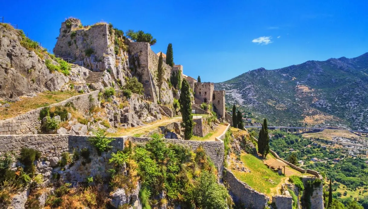
Choosing to leave behind the (wonderful) Dalmatian coast, one takes a road that leads to a narrow belt of mountains separating the Kozjak massif from the Mosor. Right on this natural threshold rises the Klis Fortress, built along a limestone cliff that rises to 385 meters above sea level.
From this height the gaze extends toward the profile of the Adriatic islands, also because for centuries the passage between the coast and the hinterland has been a military and commercial crossroads of enormous importance: the fortress indeed controlled one of the main access routes to the Dalmatian coast.
Its walls follow the shape of the mountain and from afar they nearly blend with the rock.
Brief History of the Klis Fortress
The earliest traces of habitation in this area of Croatia date back to the late Neolithic, between 6000 and 4500 BCE, a period associated with the Impressa culture. The oldest inhabitants known with precision are the Dalmati, a people belonging to the Illyrian world. On the heights they built fortified settlements aimed at controlling passes and territory.
With the Roman conquest, a military outpost arose to defend Salona. In late antiquity the structure was known as Kleisa, but, after the fall of the Western Roman Empire, the territory passed under Byzantium. In 614, according to the account of the emperor and historian Constantine Porphyrogenitus, the fortress fell during the Avar-Slavic advance and Salona was subsequently sacked and destroyed.
An 852 map cites the fortress among the holdings of Prince Trpimir. In the centuries that followed it became one of the centers of Croatian power, and its position proved decisive during the Tatars’ invasion of the Hungarian-Croatian kingdom. Historical tradition indeed links Klis to the king Béla IV taking refuge from the advance of the Horde.
From the 15th century it stood on the frontier between the Ottoman Empire, the Republic of Venice, and the Habsburg monarchy. In this phase the Uskoci appeared, fighters specialized in rapid incursions into enemy territory. Their most famous commander was Petar Kružić, who defended Klis for over 20 years against Ottoman forces.
In 1537 the resistance ended and the fortress passed to the Ottomans. Then, in 1596, a group of Croats managed to seize it with a surprise attack, but in the same year an Ottoman counterattack forced the defenders to retreat. The Ottoman phase lasted a total of 111 years.
The definitive turning point arrived in 1648, during the war of Candia between Venice and the Ottoman Empire: Klis was conquered by Venetian forces and remained under Venice until 1797. French and then Habsburg rule followed.
Visiting the Klis Fortress among Gates, Bastions, and Saint Vitus Church
The visit follows the structure of the complex itself. Three gates progressively lead toward its more interior parts, in a route that allows you to sense the shift from a residential function to a purely defensive one.
The first entrance dates back to the 1820s and was built by the Austrians on the site of a previous Venetian gate. Beyond this point, the path climbs toward the second gate, tied to the medieval fortress and later renovated by the Austrians. The third retains medieval origins and was modified several times by the Venetians, with the last intervention dated 1763.
Inside one finds the former governor’s residence, also called the Prince’s House. The building dates to the mid-17th century and rests on the foundations of older structures linked to the Croatian rulers and the later governors of Klis. In Austrian times it housed the fortress command.
One of the most distinctive features is the Saint Vitus Church, because its history encapsulates another power shift: after the Ottoman conquest of 1537, the building was transformed into a mosque, with a square plan, hemispherical dome, and a minaret. Following the Venetian conquest of 1648 it was reconverted to Christian worship and dedicated to Saint Vitus. Above the entrance there is a Latin inscription dating to 1743.
Beside the church sits the Bembo Bastion, the largest artillery space in the fortress’ third defensive system and in the entire fortress. The current structure dates to the mid-17th century and occupies the site of the former Kružić tower.
The small museum collects weapons and objects tied to Klis’ long military history. Among the exhibited pieces are swords, muskets, armor, and reconstructions of the Uskoks’ clothing. The historical panels help trace a complex saga, marked by political successions and sieges.
Then comes the overlook: from the highest part the fortress opens toward Split, the plain, and the Adriatic. After passing through courtyards, staircases, and stone passages, the view shifts in scale, with the city appearing below, while the fortress reveals the reason for its fame as the “Key to Dalmatia,” a designation tied to its strategic position.
Klis has also earned a place in television imagination, as it was used for filming Game of Thrones and represented Meereen in the fourth season. A small exhibition dedicated to the series preserves images and material from the shoot.
Where it is and how to reach it
Klis is located about 11-13 km from the center of Split, perched above the plain of the same name. The fortress sits on the pass between Kozjak and Mosor, at nearly 350 meters above sea level, with the highest point of the complex at 385 meters. Driving is the simplest solution. The route follows the old road from Solin and allows reaching the fortress area, with free parking at the lower part of the complex near the entrance.
From Split there are also local buses 22 and 35 departing from the Sukoišan terminal, with a stop near the fortress. Cycling is also a possibility, thanks to the NextBike station present in Klis. The climb is steep, so an electric bike is particularly suitable.
The visit takes roughly 1 hour to 1 hour and 30 minutes. In summer the sun can be intense and shaded areas are limited, while the terrain features slopes and steps.
