
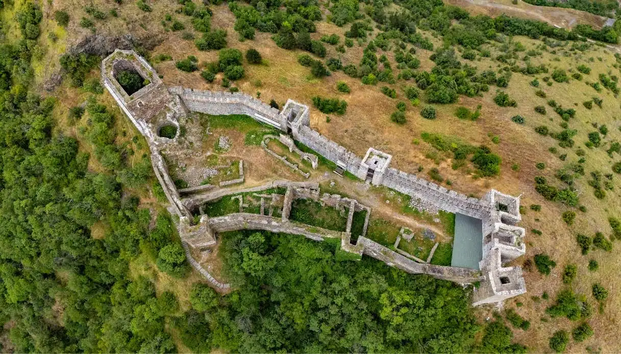
It isn’t hard, especially when viewed from afar, to mistake it for a gigantic crown of stone perched atop a mountain, while at its feet the Ibar river traces an extremely tight bend that resembles a necklace. The water seems almost to protect a small medieval kingdom from the rest of the world, a timeless wonder that corresponds to the Maglić Fortress.
We are in Serbia, a short distance from Kraljevo, in a territory that during the Middle Ages represented the political and religious heart of the kingdom. The fortress sits on a rocky spur about 100 meters high, in a panoramic position chosen to make conquest exceedingly difficult: three sides are naturally protected by steep slopes and by the river, while the fourth was defended by a moat carved into the rock.
For its shape and mysterious atmosphere it is nicknamed “Serbian Camelot”, in reference to the legendary castle of King Arthur. The name itself endows it with even more charm. Maglić derives indeed from the Serbian word magla, which means fog, a phenomenon frequent in the valley and responsible for a particularly evocative scene in the early hours of the morning.
Brief History and Legends of Maglić Fortress
Determining who built Maglić is, at present, impossible. Even today, the question remains open, although archaeological investigations have identified traces of an earlier fortification, probably dating to the twelfth century. What is certain is that the current building took shape mainly between the late thirteenth and the early fourteenth century, although some reconstructions place its founding earlier.
Between 1324 and 1337, Maglić was expanded and enriched with residential buildings, spaces for the clergy, and religious structures. The Church of Saint George received new architectural elements, while the interiors were decorated with frescoes.
With the Ottoman advance, this Serbian treasure gradually lost its original role: it passed under Turkish rule probably around 1455 and housed a garrison charged with monitoring communications along the Ibar. It later returned to the center of clashes during the wars between the Habsburgs and the Ottomans and, in 1815, was involved in the military episodes of the Second Serbian Uprising.
Beside the historical documents survive tales handed down for generations. One attributes the fortress’s construction to Prokleta Jerina, the “Maledetta Jerina”, wife of the despot Đurađ Branković, a figure in local folklore associated with numerous castles and the sufferings of workers employed in their construction. For this reason Maglić is sometimes called Jerinin grad, the City of Jerina. The legend, however, presents an evident chronological problem, since the noblewoman lived in the fifteenth century, thus long after the fortress’s initial construction phases.
Even more romantic is the tradition linked to the Valley of Lilacs (the territory under the fortress). According to the story, King Stefan Uroš I would have planted numerous white and blue lilacs along the Ibar to welcome his future bride Elena of Anjou and to remind her of the landscapes of her homeland. A gesture of love that became part of the local imagination, although there is no historical proof of its actual realization.
Another belief concerns the last battle fought near the castle: on the eve of the Feast of Saint Peter, the mountains would still echo with the sounds of the clashes of 1815.
Visiting Maglić Fortress
The first sensation when viewing it from below is that it seems unattainable. Fortunately, “it’s enough” to climb along the rocky slope to gradually appreciate the imposing defensive structures. After passing the entrance, the space opens up to a complex of walls, towers and remains of buildings that reveal the layout of a medieval citadel.
Maglić possesses eight towers in total, seven arranged along the perimeter of the fortifications and a formidable keep, the main tower intended for ultimate defense. The latter reaches about 20 meters in height, while the others generally rise to around ten meters.
The walls, built mainly with local stone and lime mortar, reach nearly two meters in thickness and follow the irregular topography for a perimeter of about 270 meters, enclosing an area a little under 2,200 square meters.
The main entrance opens on the northern side, but there is also a smaller opening located in the southeast sector. On the side facing the Stolovi mountains there is instead the artificial moat that constituted an additional obstacle for potential attackers.
Inside, the remains of the medieval palace allow us to recognize the spaces belonging to the residential section. During the thirteenth-century expansions, the building was given a upper floor with a hall illuminated by four windows. Other buildings housed accommodations, service rooms and areas reserved for daily activities.
Among the most interesting testimonies is the Church of Saint George, a small religious building with a single nave. Excavations have brought to light traces of mural decorations and transformations carried out during the 14th century. Nearby, a small necropolis has been identified, a feature rather unusual for a fortification lacking a real urban settlement.
There are also the remains of an ancient bakery and two cisterns used to store water, a resource indispensable during sieges. This detail reveals how carefully the survival of the inhabitants was planned in the event of extended isolation.
What deserves special attention, however, is the view: from the accessible areas the eye follows the course of the Ibar through a succession of bends, green slopes and mountains. Today Maglić also preserves sectors in ruins and exposed passages, so visiting requires caution, appropriate footwear for rough paths, and attention to the condition of the structures. Accessibility also depends on crossing the river, which requires specific organization.
Where Maglić Fortress Is and How to Reach It
Maglić Fortress is a Serbian jewel perched above the Ibar Gorge, around 20 kilometers in a straight line from Kraljevo and about thirty kilometers along the road toward Raška and Novi Pazar. It belongs to the Stolovi mountain landscape, in a region characterized by deep valleys, forests and ancient routes of travel.
To reach the area, take the road from Kraljevo that follows the river southward. The castle appears atop the rise, easily recognizable by the succession of towers and walls that shape the mountain’s profile.
A crucial aspect, however, concerns crossing the river: in June 2020 a flood destroyed the old pedestrian bridge, breaking the traditional link to the ascent path. Since 2022, thanks to the volunteer association Maglićgrad, a raft transport service has been reactivated.
The crossing has made it possible again for many visitors to reach the complex, but it depends on the season, the water level, and the service’s availability. If in summer there are generally no issues, for autumn and winter visits it is essential to pre-check the actual operation of the link, also through the tourism organization of Kraljevo.