
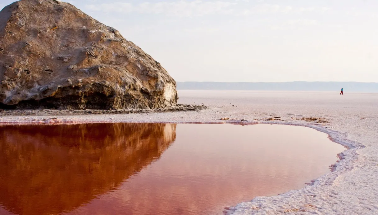
Close your eyes and try to project in your mind the image of an absolute white, a mineral crust that beneath the afternoon sun shines so brightly that it hurts the eyes. You should picture only that, because around there isn’t a shadow of any mountain and even any other kind of landmark is practically absent. A clear, vast expanse, so expansive that it seems to stretch right into the sky. Here and there pink patches appear, thin violet veins, and green reflections. Then, in the distance, something resembles a sheet of water.
It is Chott el Jerid, one of the largest salt lakes in North Africa, an extraordinary natural depression in the southwest of Tunisia. Covering an area of about 5,000 km², it presents a markedly changing appearance over the year: winter rains can transform some areas into shallow ponds, while during the hottest months evaporation reveals a cracked mineral crust. Under the summer sun, with temperatures that can reach 50 °C, the surface becomes a mosaic of crystals.
But behind this apparent stillness lies an ecologically valuable environment as well. Since 2007 the Chott el Jerid has been recognized by the Ramsar Convention as an internationally important wetland.
The origins of Chott el Jerid, the formation of the lake, and the legends
The origin of Chott el Jerid is closely linked to the northern Sahara’s geological history. The lake sits in a broad depression between the ranges of the Sahara Atlas and the southern desert platform. Over extremely long periods, the movements of the Earth’s crust and the accumulation of sediments have helped shape the basin, creating the conditions for the formation of a saline plain.
The waters come entirely from rainfall, from temporary courses called wadis, and from underground aquifers, later evaporating due to the arid climate. The dissolved minerals remain on the ground and progressively concentrate. Thus, rock-salt deposits, mainly sodium chloride, and gypsum are formed. The subsequent flooding phases modify the crust’s thickness and structure.
< /ask-ai-widget>
Even before geological studies, however, the territory had already fueled fascinating tales. Some scholars identified Chott el Jerid with the legendary lake Triton, mentioned by ancient authors. According to a story passed down by Herodotus, Jason and the Argonauts would have become trapped in its waters before receiving the help of the sea god Triton.
In the 1800s, the myth of the Sahara sea even inspired an engineering project: the French officer François-Élie Roudaire imagined linking several Sahara saline depressions to the Mediterranean through a system of channels fed by the Gabès gulf. The undertaking would have created a vast internal sea, but technical difficulties and errors in altimetric assessments led to its abandonment in 1882.
That tale also captivated Jules Verne, who drew inspiration for The Sea Invasion, a novel published in 1905. Chott el Jerid also appears in the literary world of writer Frank Heller, author of The Thousand and Second Night.
Visiting the Chott el Jerid, among salt crystals, mirages, and Star Wars locations
It is a salt lake, yes, but the most practical way to visit this corner of Tunisia is to traverse it by car. There is indeed a paved road that connects Kebili to Tozeur that winds for tens of kilometers, where the route runs on a raised embankment surrounded by the salt plain. It goes without saying (though it’s amazing to experience): the impression is like traveling over a borderless surface, with the sky reflected in the pools and the mountains reduced to distant silhouettes.
It’s worth making stops at accessible points along the way. Up close, the crust reveals small fractures, translucent crystals, and irregular crusts. Some pools take on pink tones, others lean toward green. The phenomenon depends on the water’s chemical composition and the presence of organisms adapted to extremely saline environments.
Particularly fascinating are the mirages, common around the hottest hours of the day. The temperature difference between the air layers near the ground alters the path of light rays, producing distorted images. Along the crossing you’ll also encounter stalls selling local minerals. Among the most distinctive items are the desert roses, clusters of gypsum crystals arranged in petal-like shapes.
And then there’s cinema: in 1976 George Lucas chose the western edge of the Chott el Jerid, near Nefta, to shoot some scenes from the first Star Wars, released in 1977. The salt plain became part of the imaginary planet Tatooine and hosted the exterior shots of the Lars family farm, Luke Skywalker’s home.
The small white structure, igloo-like, has become a shrine for fans of the saga. After being damaged by the elements, it was restored in 2012 thanks to the efforts of a group of fans. To reach the isolated set, it’s advisable to rely on a local guide, checking the ground conditions and any access restrictions.
The most pleasant period for visiting runs from October to April, while in summer you’ll need plenty of water, sun protection, and sunglasses to combat the glare.
Where it is and how to reach the Tunisian desert
Chott el Jerid lies in southern Tunisia, between the governorates of Tozeur and Kebili, south of the Atlas ranges. The basin runs predominantly from west to east and continues toward the Chott el Fejaj, another large salt depression. Its location makes it easy to include it in a route dedicated to oases and the Sahara landscapes of Tunisia.
Tozeur represents one of the main starting points (and also a reason to visit): an ancient caravan city, it preserves historic districts characterized by facades in small ochre-colored clay bricks, arranged to form diamonds, zigzag patterns, and raised geometric decorations.
From the eastern side access is via Kebili, an important center of the Nefzaoua region, or from Douz, considered one of the Sahara’s gateways. Those staying on the island of Djerba can reach the region by car in about 300 km to the crossing area, planning at least four hours of travel depending on the chosen itinerary.
For a broader itinerary, the crossing through Chott el Jerid can be combined with the mountain oases of Chebika, Tamerza and Midès, famous for their rocky canyons and springs, or with the villages of Sabria, Nouil and El Faouar, on the edge of the dunes.