
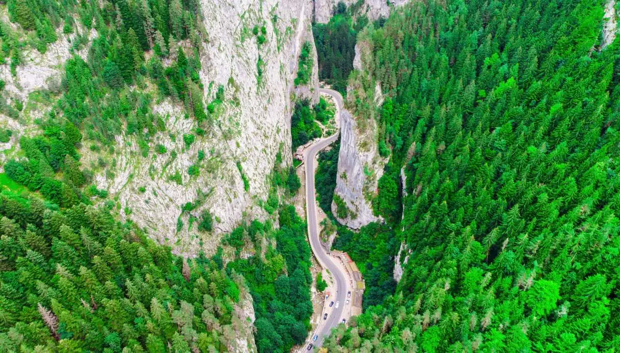
Between the mountains of eastern Romania, a road can become a true scenic experience, one that stirs the emotions. This happens along the Bicaz Gorges, a spectacular rock incision carved by the DN12C, the national road that links Transylvania to Moldova. The Bicaz River runs at the bottom of the gorge, while limestone walls rise hundreds of meters high on both sides, progressively narrowing the passage until there is barely room for the roadway, the water, and a sliver of sky.
We are in the Eastern Carpathians, inside the Bicaz-Hășmaș National Park, where curves, tunnels carved into the mountains, overhanging cliffs, springs, and waterfalls accompany the route for several kilometers. In some sections the roadway passes beneath limestone overhangs, while the Bicaz runs only a few meters away. Further ahead the valley tightens again and the most famous stretch appears, known as the Hell’s Gorge, or the Devil’s Gorge, in Romanian Gâtul Iadului.
A little further on (and almost unbelievably) the landscape changes once more: the mountain gives way to Red Lake, born from a large landslide, while trails and viewpoints allow visitors to look down on the gorges from above.
Origin and Formation of the Bicaz Gorges
The walls of this Romanian jewel are made of Jurassic limestones, sculpted over millions of years by the erosive work of the Bicaz River and its tributaries. Water gradually wore away the mountain, digging an ever-deeper passage into the limestone mass of the Hășmaș Mountains.
Today what a visitor traverses is a canyon of imposing scale, with rock faces reaching well over 300 meters in height in certain sections and taking on varying shapes along the route. Among the most recognizable formations is Piatra Altarului, also called the Altar Stone, a large rock formation that rises to nearly 1120 meters.
< /ask-ai-widget>
Even the water tells the long transformation of the land: the Bicaz River originates from Red Lake and flows through the entire gorge system, receiving numerous minor streams. The Cupaș forms the Gorges of Cupaș, the Lapoș those of Lapoș, the Bicăjel crosses the Gorges of Bicăjel, and the Șugău feeds the Gorges of Șugău. In some stretches there are waterfalls and rapids, while karst springs well up directly from the rock face.
In the narrowest sector, near Hell’s Gorge, the water accelerates, forming vortices and rapids. The erosive force of the river is also evident in the cavities carved into the rock by the continuous water movement. A related geological story concerns the nearby Red Lake, located at the western end of the gorges: a large landslide blocked the valley in 1837, and the water remained gathered, forming the lake, on the surface of which are still visible the trunks of submerged trees.
Visiting the Bicaz Gorges Between Road, Rocks, and Trails
The most immediate way to discover the gorges is to drive along DN12C, which is fully paved and open to traffic. The road winds through the canyon with tight curves, switchbacks, and short tunnels, often keeping the rock on one side and the course of the Bicaz on the other.
The pace of the journey changes with the width of the valley: in the broader sections there are spots to stop and admire the walls, while in the narrow passages the sensation is that of entering inside the mountain. The Hell’s Gorge represents the most spectacular point of the route, with vertical walls that come within mere tens of meters of each other and, in some stretches, only a few meters of space remain.
The rocks also attract climbing enthusiasts. The sheer faces host several equipped routes and during the favorable season it is possible to encounter climbers tackling the limestone cliffs. For a different perspective of the canyon one can follow the path toward Suhardul Mic, an accessible route of about 3 km that features a viewpoint facing the gorges and the surrounding mountains.
Other trails cross the Gorges of Bicăjelului and reach more secluded areas of the park, while the route toward Piatra Altarului presents more technical characteristics. The area is also home to fauna particularly linked to montane and rocky environments. Among the animals reported are brown bear, lynx, deer, and wolf.
Bird species typical of cliff habitats are also present, including the wallcreeper and the common swift. Among possible sightings are even the golden eagle, the sparrowhawk, the capercaillie, the three-toed woodpecker, the black woodpecker, the nutcracker, and the water ouzel. The area also hosts the rare Apollo butterfly.
A stop at Red Lake completes the visit nicely: the basin lies a few kilometers from the gorges and still preserves the trunks of trees left trapped after the landslide that created it. Around it there are some trails and options for water activities, creating a striking contrast with the rocky canyon environment.
Along the road one also encounters stalls run by local artisans, especially handmade ceramics, wooden objects, embroidered fabrics, sheep cheese, and preserves of wild fruits. The presence of these small activities, needless to say, adds a human dimension to a landscape dominated by stone.
Where They Are and How to Get There
The Bicaz Gorges are located in northeastern Romania, between Neamț and Harghita counties, in the Eastern Carpathians. The stretch traversed by the DN12C connects the Gheorgheni area in Transylvania with Bicaz, in the historic Moldavia region of Romania. The road constitutes one of the most engaging elements of the visit. From Gheorgheni one takes the DN12C toward Piatra Neamț, passing by Red Lake before entering the gorge sector. From Piatra Neamț one reaches Bicaz via the DN15, then continues on the DN12C toward Gheorgheni.
Travel by car is undoubtedly the most practical way to explore the area, particularly to combine the canyon, Red Lake, and the park’s trails. The route features twelve switchbacks and several very narrow stretches, with higher traffic during the peak season. For this reason, the road should be navigated with particular care, especially in busy periods.
The Bicaz Gorges also serve as a natural pass between two great historical regions of Romania: on one side Transylvania, on the other Moldavia. In fact, the road crosses the geographical boundary between these territories, tracing a valley that for millions of years has been carved by water.
