
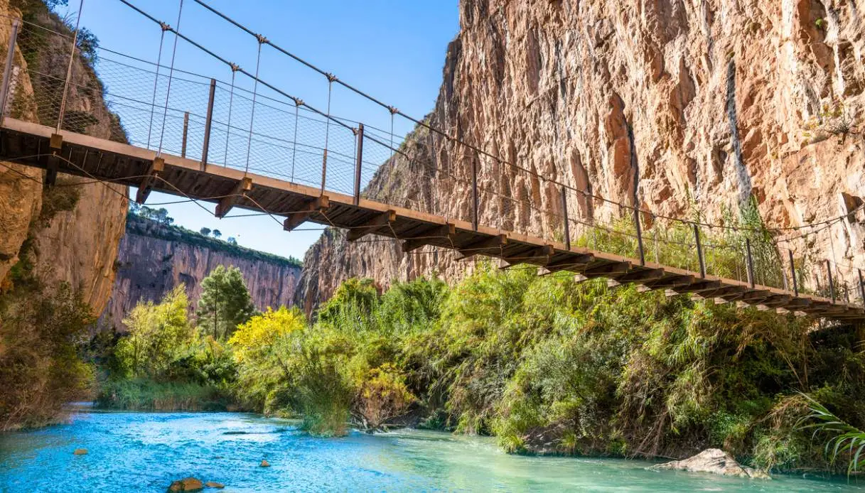
The inland of the Valencian Community hides geological secrets capable of completely overturning the stereotyped image of crowded beaches and the sandy coastlines of eastern Spain. About 50 kilometers from the coast, in fact, the landscape yields to imposing limestone formations carved from the land by millennia of fluvial erosion. Here the Turia has carved for centuries a deep limestone gorge, a succession of vertical walls, tight bends, woods and natural terraces.
Then comes the moment to enter the canyon: the Ruta de los Pantaneros (or Ruta de los Puentes Colgantes) did not originate as a tourist trail. For about 5.05 kilometers, it traces the old path that, in the 1950s, the workers of Chulilla walked daily to reach the Loriguilla Embalse construction site. The route winds through the Paraje Natural Municipal Los Calderones, a protected area of just over 500 hectares dominated by these narrow gorges.
The most unforgettable moment arrives when the suspension bridges appear. But first, one must observe the gorge. Because it is precisely its walls, shaped by water, that give meaning to the entire route.
Origin and Formation of the Turia Canyon
The canyon arises from the erosion exerted by the Turia on the limestone rock. The river gradually cut into the ground, following fractures and more vulnerable zones of the rock, until it created a narrow and deep gorge. Today what we can admire is a landscape of vertical walls, spurs, bends and environments so tight that there is almost room only for the water.
In the Los Calderones area the gorge takes on its most spectacular aspect: the walls exceed 80 meters in height and, near La Hoz, the formation becomes even more extreme. The erosion, in fact, here produced “walls” up to 160 meters high and left in some spots barely 10 meters of space for the river to pass.
Precisely La Hoz preserves one of the most curious stories connected to the canyon: before the construction of the large water reservoirs, the Turia carried a greater discharge and was used to transport logs from the mountains of Moya and from Castile toward Valencia. The madereros, workers tasked with guiding the timber along the river, had to confront the tight squeezes of the gorge and especially the points where the logs ended up getting jammed.
La Hoz represented one of the most difficult passages, because a jump of water impeded the flow of timber and some men had to descend into the gorge to free the jammed trunks. A risky task, carried out in an environment already hard to reach. The memory of those workers also remains in the ‘Ermita de San José de los Gancheros, a 17th-century building linked precisely to the presence of the madereros.
Much more recent is the story of the Pantaneros. In the 1950s the trail was walked by the inhabitants of Chulilla who were working on the Loriguilla reservoir. What today appears as a spectacular natural excursion thus represented a daily commute to the workplace.
Even the bridges themselves tell a water-soaked history: the original crossings were destroyed by the Turia’s great flood of 1957, the same flood that heavily struck Valencia. The current structures were rebuilt in 2013, while preserving the fundamental function of the old route: to connect the two banks of the gorge.
Visiting the Canyon and the Suspended Bridges
We start from the heart of the town, from Plaza de la Baronía. The trail gradually leaves the streets of Chulilla, passes the Albergue El Altico and, shortly after, enters the Turia Canyon proper. About 3 hours are needed for the 5.05 km route, rated as moderate in difficulty.
From the very first meters it is wise to look out carefully: below appears the Charco Azul, one of the most photographed spots in the entire canyon. It is a small pool of intense blue, enclosed by tall rock walls, which immediately conveys how narrow and vertical this gorge is.
Further ahead the path follows the upper edge of the precipices. The vegetation gradually changes, transitioning from the riparian forest near the water to the Mediterranean scrub of the drier zones. Below, the Turia continues to follow the bottom of the gorge; above, the limestone walls become the terrain of climbers, with sport routes that have transformed Chulilla into an international climbing destination.
At a certain point, finally, the suspended bridges appear. The first crosses the gorge about 15 meters above the river and measures 20 meters. The wooden structure is relatively short, but the position completely amplifies the sense of height. Stop for a few seconds in the middle to see the canyon open beneath your feet, with the walls rising on either side and the Turia much lower down.
The second is longer, almost 28 meters, and sits a little over 5 meters above the river. The perspective changes, and so does the perception of the gorge. The first crossing highlights verticality; the second allows a closer look at the course of the water and the vegetation on the valley floor.
Beyond the bridges, the canyon continues to slide along the trail. In some stretches the vegetation partially hides the walls, in others the view becomes fully open again. The Pedriza represents one of the most interesting viewpoints to observe the Hoces del Turia from above. Further ahead the path reaches the Embalse de Loriguilla, the large artificial reservoir tied to the Pantaneros story.
The circular variant allows continuing on the PR-CV 77.1 and reaching about 13 km in total. The main route of the Ruta de los Pantaneros remains 5.05 km and ends at the reservoir, with a return to Chulilla along the indicated path.
Where It Is and How to Get There
The village of Chulilla lies inland in the province of Valencia, in the Los Serranos comarca, about 60 km from the city. By car from Valencia the journey takes approximately 45 minutes, following the A-3 and continuing inland toward the town. The reference point for the visit is the center of Chulilla, from which the Ruta de los Pantaneros departs. Before the hike, it’s advisable to check the conditions of the trail at the Tourist Info Chulilla, especially after recent rains or particular trail conditions.
You will need proper hiking shoes, water and comfortable clothing. The first 50 meters of the route require particular attention, especially with children, while the suspended bridges should be crossed carefully and in accordance with the posted number-of-people guidelines.
The beauty of the Turia Canyon lies exactly in the shift of perspective: from the village it appears as a gigantic fissure in the mountains, while from the trail it becomes a maze of limestone walls where the bridges allow you to perceive a depth that seems almost infinite.
