
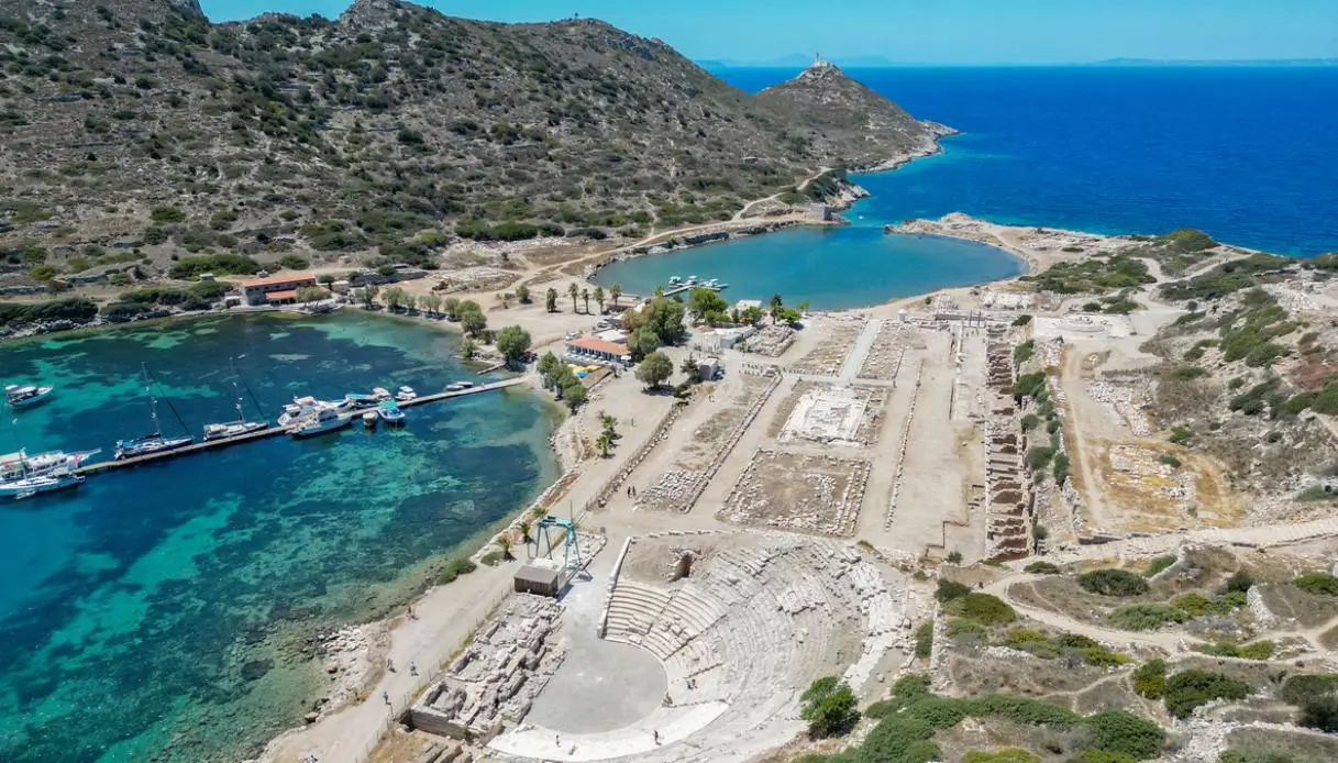
At the westernmost tip of the Datça Peninsula, the land narrows down to Cape Tekir and gives way to a blue expanse whose character changes from one flank to the other. And occupying this geographic boundary between the Aegean and the Mediterranean is Knidos, in a position that in antiquity granted it a privileged role on maritime routes.
Strabo described it as the appearance of a double city: the urban core stretched across the mainland and Kap Krio, an old island later linked to the mainland by an artificial isthmus. Knidos, among other things, grew on rugged and irregular terrain. The buildings were laid out on terraces, with avenues laid out according to a regular grid tied to the hippodamian urban tradition. Four main streets ran east–west, intersected by steeper paths on the opposite slope. Stairs, squares, colonnades and sanctuaries built a scenographic city, always facing the sea.
But that is not all, because the wine produced in its territory circulated throughout the ancient Mediterranean, while the cultural life drew figures connected to mathematics, astronomy, medicine and architecture. Most notably, Knidos became famous for Aphrodite: Praxiteles crafted in the 4th century BC a statue of the goddess destined for the city sanctuary, a work that entered the history of Greek art for the goddess’s full nudity.
What to See in Knidos
The visit to this jewel of Turkey makes sense when observing the relationship between architecture and the landscape. Temples, theaters, and civic spaces were arranged at different levels, almost creating a sequence of stages oriented toward the harbors. Many structures preserve mainly their foundations, walls, and fragments, so a bit of imagination is required.
View this post on Instagram
The Two Ancient Harbors
That is the most recognizable stretch of Knidos: to the north opens the military basin, smaller and protected, with remains of the tower and the breakwater. On the southern slope extended the merchant harbor, intended for ships engaged in Mediterranean traffic.
The Circular Terrace Linked to Aphrodite
In the western sector rises the terrace of the circular temple, traditionally associated with the famous cult of Aphrodite. The elevated position allowed domination over both basins and contributed to the sanctuary’s theatrical character.
It was here in Knidos that the renowned statue by Praxiteles stood: the goddess appeared nude, a revolutionary choice for 4th-century BCE Greek art and destined to influence the goddess’s iconography for centuries. What remains of the work is known from sources and later copies.
View this post on Instagram
The Small Theater and the Terrace of Dionysus
North of the main harbor lies the smaller theater, facing directly onto the seascape. The rows take advantage of the natural slope and give a sense of the close link between public performance and the coastal backdrop.
Not far away developed the Terrace of Dionysus, named for the presence of a sanctuary dedicated to the god.
The Great Theater and the Sanctuary of Demeter
On the eastern part of the mainland are the remains of the great theater and the sacred area dedicated to Demeter. The complex testifies to the scale reached by the city during its most prosperous period.
View this post on Instagram
The Necropolis and the Lion of Knidos
To the east of the settlement lay a necropolis about 7 km long, featuring burials of varied shapes and periods. Its size immediately signals the city’s significance. From an eastern hillside also came the famous Lion of Knidos, a grand marble sculpture transported in the 19th century to London and today preserved at the British Museum.
What to Do in Knidos
Knidos demands time, especially for the landscape. The wind shifts in intensity from one slope to another, boats enter the southern harbor and the archaeological terraces grant perspectives just a few meters apart. It is better to alternate ruins with scenic stops, rather than turning the visit into a dash among monumental remains.
- Watch the sunset from the theater’s seats: the oblique light accentuates the profiles of the ruins and turns the sea into a luminous band before the cavea.
- Reach the Deveboynu Lighthouse: the path climbs toward the tip of the peninsula and takes about 30–45 minutes each way depending on pace.
- Observe the harbors from above: climbing toward the western terraces clearly reveals the division between the military basin and the merchant harbor, one of the site’s most distinctive features.
- Seek traces of daily life: stalls, cisterns, streets, drainage systems and foundations tell a side of urban life that is less celebrated but essential.
- Pair archaeology with the sea: the southern harbor immediately conveys Knidos’s maritime nature and helps read the site from the perspective of ancient navigational routes.
View this post on Instagram
Where It Is and How to Get There
Knidos sits on Cape Tekir, the western tip of the Reşadiye Peninsula, in the Datça district and the Turkish province of Muğla. From Datça town, the distance is roughly 35–40 km, and the paved road winds through olive groves, almond trees, rocky outcrops and small coves, with numerous bends in the final stretch.
By car, the journey takes about 45–60 minutes, varying with traffic and stops. In the summer season, local minibuses may operate between Datça and the archaeological area, with frequencies to be confirmed on site as schedules shift throughout the year.
iStock