
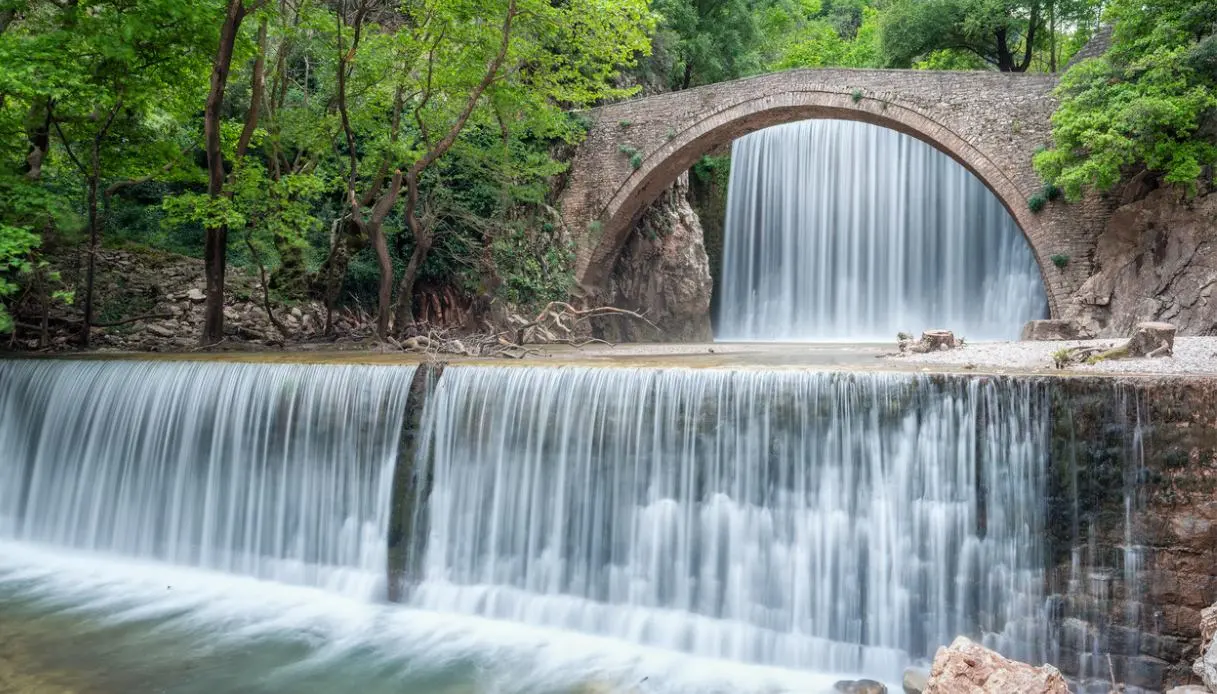
An arc of pale stone cuts across a narrow gorge, while behind it the water plunges forcefully down the rocky wall, forming a long white veil. Lower down, a second, much smaller drop completes the scene. Around, trees and shrubs of riparian vegetation grow; the rocks rise steeply on either side, and the sound of the Palaiokaritis fills the air.
The Palaiokarya Falls, in the Greek region of Thessaly, conceal a peculiarity that initially escapes notice: the two cascades originate from two small barriers built in the 1970s. The main one reaches about 12 metres, the lower barely 2 metres. Yet the result seems as if it has always belonged to the landscape. The medieval bridge before the jet makes the scenery even more dramatic and has transformed this corner of central Greece into one of the most photographed spots in the Trikala area.
Beauty arises mainly from the encounter between nature and history. The bridge dates from the 16th century, while the river flows through a geological formation far older, shaped by movements that gave birth to the Pindos range. The small complex lies about 500 metres from Kato Palaiokarya, within the Palaiokarya Gorge, also known as Gropa.
Origin and history of Palaiokarya
The Palaiokarya Bridge is generally dated around 1550. There are no written records to pinpoint the exact year, so dating relies mainly on local tradition and the architectural features of the structure. The bridge features a single large stone arch, about 26 metres in length, with an opening of nearly 19 metres and a height exceeding 10 metres.
Its position immediately reveals why the location was chosen: the river flows through a narrow crevice between nearly vertical limestone walls, creating a natural crossing point well suited for construction. For centuries the bridge linked Pyli with the villages of the Aspropotamos area and with routes toward Epiro, becoming an important passage for people, animals, and goods.
The geological history of the landscape is far older still. The rocks belong to the Pindo zone, a large geological unit formed through the deformation of marine sediments laid down in the ancient ocean of the Tethys. During the Alpine orogeny (which began tens of millions of years ago) these materials were compressed, folded, and lifted to create the mountains that today characterize broad areas of Greece.
Erosion has progressively stripped away the more vulnerable layers, while the tilt of the rock formations has favored the creation of a very narrow passage. Palaiokaritis has continued to carve the landscape, fed by the waters descending from the mountains. The waterfalls, on the other hand, belong to more recent history: in the 1970s two small barriers were built, one behind the bridge and one on the opposite side. From these works come the two drops that today almost seem an intrinsic part of the gorge.
The visit among the waterfall, the bridge, and old crafts
The most striking vantage point is easily reached. After parking, a short walk along the brief dirt road leads to the bridge. The distance from the main road is about 100 metres, and up close the bridge looks far more imposing than in photographs.
The arch follows the contour of the gorge, and the masonry sits among the rocks with surprising natural integration. At the rear, the main jet falls from above and vanishes into a pool at the base, while the vegetation frames the scene. The optimal spot to take in the whole view is in the area in front of the bridge.
From that angle the arch, the larger drop, and the gorge walls all share the same frame. In the morning the light can emphasize the rock surfaces, while on autumn days the contrast between foliage and stone gives the landscape a particularly intense feel.
The pool at the base of the cascade can invite a swim, but one must be aware that the Palaiokaritis water is very cold. The wet rocks also demand caution, especially near the main drop. For a quiet pause, simply reach the open area beside the bridge, listen to the water, and observe the landscape without tackling demanding paths.
It is worth continuing toward Kato Palaiokarya to reach the old water mill and the dristela, a traditional device once used to wash blankets, carpets, and heavy fabrics. The moving water replaced much manual labor and transformed the river course into an essential tool for the community. In the area, you can still glimpse the traditional system linked to grinding cereals.
The landscape deserves attention beyond the bridge: the Katouna forest, rich in firs and oaks, accompanies the gorge toward the mountains, while the summits of Gropa and Karava define the wildest scenery of the area. An ancient stone path finally connects the Gropa area with Ano Palaiokarya.
Where it is and how to get there
Palaiokarya sits in the Trikala regional unit, in western Thessaly. The waterfall is about 35 km from Trikala and nearly 11 km from Pyli, one of the region’s main hubs. The site lies roughly 500 metres from Kato Palaiokarya, along the provincial road that crosses the upland valley. From Pyli, follow the road toward Stournareika.
Along the route, signs point to Ano Palaiokarya, Mesi Palaiokarya, and Palaiokarya. After passing the junction indicated by local signage, a short dirt road leads to the bridge. The last 100 metres are drivable with care, then the site is reached on foot in a few minutes.
Visiting requires only a short time, but it is worth allowing for a longer pause: the place carries a special character precisely because it brings together in a single space a historic bridge, a calcareous gorge, a perennial watercourse, two artificial waterfalls, and tangible traces of mountain rural life.
Palaiokarya thus remains one of those spots capable of surprising especially for the perfect balance between the elements. The bridge belongs to history, the river to geology, the forest to the landscape, and the waterfalls to the ingenuity of rural life in the 20th century. Together they form a scene that seems to have stepped out of an old tale, yet carries a far more intricate and real history.
